


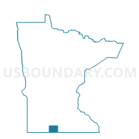
Pleasant Prairie Twp. Voting District, Martin County, Minnesota
About
Outline

Summary
| Unique Area Identifier | 603087 |
| Name | Pleasant Prairie Twp. Voting District |
| County | Martin County |
| State | Minnesota |
| Area (square miles) | 35.91 |
| Land Area (square miles) | 35.70 |
| Water Area (square miles) | 0.21 |
| % of Land Area | 99.42 |
| % of Water Area | 0.58 |
| Latitude of the Internal Point | 43.63695190 |
| Longtitude of the Internal Point | -94.31651510 |
Maps

Graphs
Select a template below for downloading or customizing gragh for Pleasant Prairie Twp. Voting District, Martin County, Minnesota


Neighbors
Neighoring Voting District (by Name) Neighboring Voting District on the Map
- Center Creek Twp. Voting District, Martin County, MN
- East Chain Twp. Voting District, Martin County, MN
- Fairmont Twp. Voting District, Martin County, MN
- Jo Daviess Twp. Voting District, Faribault County, MN
- Pilot Grove Twp. Voting District, Faribault County, MN
- Rutland Twp. Voting District, Martin County, MN
- Silver Lake Twp. Voting District, Martin County, MN
- Verona Twp. Voting District, Faribault County, MN
Top 10 Neighboring County Subdivision (by Population) Neighboring County Subdivision on the Map
- Silver Lake township, Martin County, MN (519)
- Rutland township, Martin County, MN (437)
- Verona township, Faribault County, MN (364)
- Fairmont township, Martin County, MN (318)
- East Chain township, Martin County, MN (296)
- Jo Daviess township, Faribault County, MN (245)
- Pleasant Prairie township, Martin County, MN (243)
- Center Creek township, Martin County, MN (217)
- Pilot Grove township, Faribault County, MN (156)
Top 10 Neighboring Unified School District (by Population) Neighboring Unified School District on the Map
- Fairmont Area School District, MN (12,890)
- Blue Earth Area Public School District, MN (8,139)
- Granada-Huntley-East Chain Public School District, MN (1,850)
Top 10 Neighboring State Legislative District Lower Chamber (by Population) Neighboring State Legislative District Lower Chamber on the Map
Top 10 Neighboring State Legislative District Upper Chamber (by Population) Neighboring State Legislative District Upper Chamber on the Map
Top 10 Neighboring 111th Congressional District (by Population) Neighboring 111th Congressional District on the Map
Top 10 Neighboring Census Tract (by Population) Neighboring Census Tract on the Map
- Census Tract 7902, Martin County, MN (2,587)
- Census Tract 7903, Martin County, MN (2,430)
- Census Tract 4603, Faribault County, MN (1,995)
- Census Tract 7904, Martin County, MN (1,939)